
")
Mount Rainier is one of the most awe-inspiring mountains that I have ever seen. Being a Seattleite, I’ve mused at it thousands of times from a distance. But, there is nothing like being right there in the shadows of this active volcano rising to 14, 411 feet. Mount Rainier National Park comprises 369 square miles of natural beauty. It’s essential to plan to get the most out of your time here. So, here’s the 10 best Mt Rainier highlights to navigate this national park.
“Of all the fire mountains which like beacons, once blazed along the Pacific coast, Mount Rainier is the noblest.” – John Muir
Mt. Rainier is part of the Pacific Ring of Fire on the Pacific Rim where our planet’s largest volcanoes and earthquakes loom and rumble. Mount Rainier National Park has 5 developed areas: Longmire, Paradise, Ohanapecosh, Sunrise, Carbon River and Mowich. The Paradise area on the southside of Mt. Rainier is open all year round. At elevations over 5,000 feet, the snow doesn’t melt completely until July. Therefore, in May or June be prepared for hiking on snow. In contrast, the Sunrise area on the northeast side sits at elevations over 6,000 feet. So, at Sunrise the mountain opens only from July to late September due to more snow.

Top Ten Mt Rainier Highlights & Best Things to Do
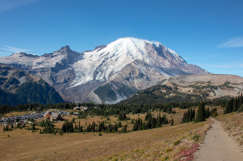
1. Paradise

Paradise more than lives up to its name. And if you only have one day at the park, this is the place to go. At 5,400 ft. this is the gateway to the southern side of majestic Mt. Rainier, showcasing meadows and glaciers. However, as the most popular location at Mt. Rainier, you must arrive before 9 am or after 5 pm to find a parking spot during the summer months. Paradise is open year-round, with snow that doesn’t melt until end of June. It’s the ultimate paradise to hike in the summer and snowshoe in the winter.
Henry M. Jackson Memorial Visitor Center offers educational displays and literature to learn about the geology, flora and fauna of the region. There are free, helpful wildflower guides to identify while exploring the area. And the friendly rangers are there to answer your questions. It’s a good starting point if you want to gather information and learn.
Walking distance from the visitor’s center is the historic Paradise Inn, originally built in 1916. This rustic lodge is made out of cedar logs and is listed on the National Register of Historic Places. It’s the ultimate accommodation at the park with extraordinary views of Mt. Rainier and immediate access to hiking trails and wildlife, such as, deer, marmots and black bears.

There are numerous hiking trails from the Paradise parking lot. The most popular is the Skyline Loop Trail, a 5.4 moderate trail going to Panoramic Point with views of not only Mt. Rainier, but also Mt. Adams and Mt. St. Helens. This loop also goes to the pristine Myrtle Falls. Camp Muir is as high as you can go without needing a climbing permit. From paradise it’s 8 miles roundtrip, gaining 4,640 ft. The Golden Gate Trail is much easier, just 4 miles roundtrip and gaining 1,160 ft in elevation. This trail also goes to Myrtle Falls and the vibrant meadows with wildflowers in July and August.
2. Sunrise Visitor’s Center and Trails
On the northeast side of the park is the Sunrise Visitor Center at an elevation of 6,400 ft. The road to Sunrise is only open July through end of September. The views of Mt Rainier from here are some of the most dramatic in the park, with the massive Emmons Glacier and vibrant meadows with wildflowers. Being on the northeast side, there is a rain-shadow affect and the area is the first to catch the morning light.
Like Paradise, Sunrise has an educational visitors center, however, no lodging. There is a walk-in campground (1 mile) from the visitor’s center. Overall, Sunrise and Paradise are the main attractions at Mt Rainier and both extraordinary in their unique way. The hiking trails of Sunrise are just as incredible as the ones at Paradise. Mt Fremont Lookout Trail via Sourdough Ridge is one of the most scenic hikes in Washington, renowned for epic views of Mt Rainier and the Cascades.
This trail is a moderate 5.6 miles gaining 900 feet. It takes you along the craggy ridge, past Frozen Lake, the meadows and wildflowers of Berkeley Park and the mountain goats to Mt. Rainier’s highest fire lookout. Other amazing trails are the Dege Peak Trail (3.1 mile and Elevation Gain: 820 ft). and the Burroughs Mountain Trail (9.4 miles Elevation Gain: 2,562 ft).
3. Photo-op Walk at Reflection Lakes

One of the most iconic places for the perfect Mt. Rainier photo is at Reflection Lakes. Just a 10-minute ride from Paradise on Steve Canyons Road is these mirror-like lakes, near the roadside. Also, you can hike here from Paradise or Narada Falls. The best time for photography is at dawn or dusk, with calm winds and somewhat clear skies. The reflection of the south side of the mountain on the lake is crystal clear and a breathtaking photo.
4. Chase Waterfalls near Paradise

Tip: The best time of year to see waterfalls is in late spring/early summer because of the snowmelt.
The most spectacular cluster of waterfalls at Mt. Rainier are near each other close to Paradise. Myrtle Falls is just .8 mile from the Paradise Inn and is gorgeous with the backdrop of Mt Rainier behind it, cascading 72 feet to Myrtle creek. Down the road from Paradise is a series of waterfalls accessible by short hikes from the Steve Canyons Road: Narada Falls (168 ft), Christine Falls (upper drop: 32 ft / lower drop: 37 ft) and Falls Creek Falls (30 ft). Comet Falls is also well known, however, it’s a 5.4-mile moderate-difficult hike to see the 301 feet high cascade.
5. Grove of the Patriarchs (Ohanapecosh area)

The southeastern corner of Mt. Rainier is enshrouded with the most ancient old-growth forests in the park. Here, is the Packwood Visitor Center. Most noteworthy is the Grove of the Patriarchs, a trail that is about 1 mile up and back, with minimal elevation gain. This hike is perfect if you are wanting to do an easy hike or add on to a moderate trail. The ancient, old-growth path takes you over Ohanapecosh River on a suspension bridge to an island. This primeval island lies preserved from fires sustaining tree giants, such as, Douglas firs, cedars and hemlocks. Some are more than 1,000 years old and over 300 feet tall.
6. Longmire
Being at 2,700 feet, Longmire is open year-round and offers fantastic early / late season hiking trails. Even more, many trails are wonderful in the winter for cross-country skiing and snowshoeing. The Rampart Ridge Trail takes you through old-growth forest to a 4,000-ft ridgeline for amazing views. Also, the Trail of the Shadows is a .7-mile family-friendly loop hike to the old resort site, mineral springs and historic cabin. The Longmire Museum is a great place to discover the history of the area.
7. Take a Hike – Mt Rainier Highlights

The best way to see Mt. Rainier up close and personal is through hiking. Mount Rainier National Park maintains more than 260 miles of hiking trails. Many trails offer extraordinary views of her majesty and the Cascade Range. As a Washingtonian and member of Mountaineers, I have enjoyed many trails at this park.
Five top hikes at Mt Rainier are the following: Skyline Loop Trail (6.2 mi/Moderate – Hard); Summerland to Panhandle Gap Trail (8.5 mi/Moderate – Hard); Mt Fremont Lookout Trail (5.7 mi/Moderate); Naches Loop Trail (3.3 mi/Easy) and Wonderland Loop Trail (96.2 mi).
Related: Top 10 Spectacular Hiking Trails at Mt Rainier National Park
8. Carbon River / Mowich Lake
This northwest region of the park is an inland temperate rainforest. There are amazing opportunities for recreational activities here, such as, hiking, camping and mountain biking. Furthermore, the Carbon River Road is one of the few places withing the park that allows mountain bikes. Mowich Lake is the deepest and largest lake inside the park near Mowich Campground. The road to the lake is only open during the summer and closes after first snowfall.
One of the best hikes in this area is the Tolmie Peak Lookout Trail (7.5 mi/moderate). Its trailhead is reached from the rough, 17-mile Mowich Lake Road. From the campground and west side of the serene Mowich Lake the trail begins. Especially in summer, this is a great place for a swim. With fantastic views of Mt. Rainier to the south this trail takes you to the Tolmie Peak Lookout. Along the way is the vibrant Eunice Lake. From the peak is spectacular views of Mt. Rainier and the lake below.
9. Gondola Ride / Skiing – Crystal Mountain Resort

This year-round attraction is a world class destination for skiing, hiking and scenery. During winter months the gondola is available for anyone, even if you’re not skiing. During summer, the gondola opens mid-June. The gondola ride takes you 2,400 ft to the summit, where you can wander and take in 360-degree views of Mt Rainier and the Cascade Range. Once you arrive up top, Tower 16 offers snacks and beverages. For a nice splurge, there is also the Summit House, Washington’s highest elevation restaurant at 6,872 ft featuring Pacific Northwest cuisine and unparalleled views.
There are dozens of summer/fall hikes near Crystal Mountain Resort, with options for hiking one or both directions to the top of Crystal Mountain. For example, these 5 hikes are amazing: Henskin Lake, Bullion Basin Trail to the Pacific Crest Trail, Norse Peak Trail, Green Valley Trail and Northway Trail.
10. Cayuse Pass & Chinook Pass

The Chinook Scenic Byway is known as one of the most scenic drives in Washington at an elevation of approx. 4,5000 ft. This road starts in Enumclaw and ends in Naches / Tipsoo Lake. Along this drive you have fantastic views of Mount Rainier. Furthermore, Naches Loop Trail (3 mi) is a popular, family-friendly hike that is easy with incredible wildflowers and views. The Chinook Pass (5,430 ft) is located 3 miles east of Cayuse Pass on SR 410.
Overall, Mt Rainier Highlights
Mount Rainier National Park is an absolute national treasure. I am so blessed to live near it and experience the park so intimately. Therefore, I can’t recommend it enough for a must-see destination in the United States. Perhaps, nowhere in the U.S. takes you to the heart more of the Pacific Ring of Fire for an intimate exploration of this fascinating volcano and surroundings.
Read More!
Ultimate Guide to Mt Rainier National Park: All You Need to Know