

Washington state is an absolute paradise for hiking trails, immersed in diverse ecosystems and landscapes. They offer lush, old-growth rainforests, Puget Sound, alpine lakes and majestic volcanoes, such as, Mt. Rainier and Mt. St. Helens. As a Washingtonian, I can’t actually rate the best hiking trails, because of the boundless choices. However, these 20 top Washington hiking trails are among the most popular because they are so spectacular.
Overall, these 20 top Washington hikes are in the following areas: Mt. Rainier National Park, Seattle, Olympic Peninsula, North/Central Cascades and Mount St. Helens National Monument.
Also, a note on parking: most popular trails in Washington state fill up early during the warmer months, especially on weekends. So, many require an early arrival for a parking spot. The weather in Washington changes quickly. So plan accordingly and always bring your Hiking Essentials and dress in layers.
Disclosure: Please note that some of the links below are affiliate links. At no extra cost to you, I earn a small commission from each booking that allows me to keep content up to date and maintain this website.
Related: Day Hiking Essentials Checklist for a Safe Adventure with REI Favorites
20 Top Washington State Hiking Trails

Mt. Rainier National Park’s Top Trails
Mount Rainier National Park maintains more than 260 miles of hiking trails. Mount Rainier is an active volcano looming at 14, 411 feet. It’s the tallest mountain in Washington with 25 named glaciers. Many trails offer extraordinary views of her majesty and the Cascade Range. Here are my 4 favorites at Mt. Rainier:

1) Skyline Loop Trail
6.2 miles
Elevation Gain – 1,788 Ft.
Hard
Paradise Visitor Center – Mt. Rainier N. P.
America the Beautiful Pass (Buy REI)
From Paradise Visitor’s Center this loop trail takes you very close to the south side of Mount Rainier. It offers amazing views of the Nisqually Glacier. If you go counterclockwise, you can climb the steep part first. Then, you complete with a more gradual decline through the meadows. Panoramic Point is a highlight to stop for views and lunch at 6800 feet. It offers amazing views of Mount St. Helens and Adams on a clear day.

This trail is especially known for its vibrant wildflowers in July – August. Plus, it gorgeous fall colors are just as incredible. Additionally, you are almost guaranteed to see cute marmots on the trail. I happily saw a family of 7 marmots here, as well as mountain goats and a handsome buck. Others have seen black bears too.
Also, this hike includes the beautiful Myrtle Falls, cascading 72 feet with Mt. Rainier looming behind it. If you have only one day in Mt. Rainier N. P. this is a great choice, especially on a clear day.

2) Summerland to Panhandle Gap Trail
11.1 miles (Summerland Only – 8.5 miles)
Elevation Gain: 3,149 feet (Summerland only 2,100 feet)
Hard/Moderate
White River Entrance – Mt. Rainier N. P.
America the Beautiful Pass (Buy REI)
This up and back trail literally has it all! It takes you through several miles of mature forests, before reaching the subalpine meadows and upper valley of Fryingpan Creek. These meadows are especially known for their beautiful wildflowers. For example, you can see Indian Paintbrush, monkey flowers, lupine, louseworts, gentian and asters. At the meadows there is a pit toilet and picnic tables with panoramic views of Little Tahoma and Mt. Rainier summit. Also, marmot findings are common here.
Then, from ancient forests to subalpine meadows, you can continue to Panhandle Gap, for an additional 900-foot climb in 1.5 miles. Overall, this lunar landscape is a different world of large boulders, gravel, turquoise tarns, rushing snowmelt creeks and even some hardy wildflowers.
3) Mt. Fremont Lookout Trail via Sourdough Ridge Trail
5.7 miles
Elevation Gain: 1,118 feet
Moderate
Sunrise Visitor Center– Mt. Rainier N. P.
America the Beautiful Pass (Buy REI)
This is many Washingtonians favorite hike in the state because of its extraordinary views and reasonable access. From Sunrise Visitor Center this takes you along Sourdough Ridge to Frozen Lake. From here you walk along the edges of Berkeley Park, known for its incredible wildflowers and make the ascent to the lookout post.
Built in 1934, the Mt Fremont Fire lookout cabin offers amazing views of Grand Park (largest meadow in the park), Redstone Peak and Skyscraper Mountain. Overall, this is a splendid place for sunrise/sunset views and wildlife, such as, mountain goats, marmots and bears.

4) Wonderland Loop Trail
96.2 miles
Elevation Gain: 25,341
Strenuous
Access points throughout Mt. Rainier N. P.
Pass: Overnight Camping Permit
This renowned trail circumnavigates Mt. Rainier, offering the most intimate views of Washington’s tallest mountain and its 25 named glaciers. Many people break it up and hike sections at a time. While others take on the whole trail at once, obviously requiring camping permits and backpacking. However, permits are not required for day hikes.
Related: Top 10 Spectacular Hiking Trails at Mt. Rainier National Park
Seattle Area Hiking Trails
20 Top Washington Hiking Trails
5) Snow Lake Trail

6.7 miles
Elevation Gain: 1,699 Ft
Moderate
Alpental Ski Area
Northwest Forest Pass (Buy REI)
This is one of the most popular hikes near Seattle because it’s a gorgeous hike just 50 minutes east of Seattle and moderate difficulty. The trail starts off next to the S. Fork Snoqualmie River and Snoqualmie Mountain on the right. You pass by many waterfalls and steep switchbacks to the alpine lake.
Once you reach the lake, there are many routes to explore along the large boulders and rocky beaches on the shore. On a bright day, the mountainsides reflect beautifully onto the lake. For a more challenging hike, you may continue on 2 more miles to Gem Lake.
6) Kendall Katwalk
12 Miles
Elevation Gain: 2,600 Feet
Hard
Near Snoqualmie Pass
Northwest Forest Pass (Buy REI)
This incredible trail is part of the Pacific Crest Trail. Named after the narrow pathway blasted out of a steep rockface (only 160 yards long), so the PCT could reach Canada. Overall, it includes old-growth forests, wildflowers and epic views in the Alpine Lakes Wilderness below Kendell Peak.
At 4.25 miles, cross a flat ridge and steep hillside through old-growth forest, then breaking out into open talus. In July and August, the slopes display a colorful display of wildflowers. Therefore, this section is is called Kendall Gardens. The trail is steep and exposed, offering amazing views of Lundin Peak, Red Mountains and Mt. Rainier.

7) Bridal Veil Falls and Lake Serene
8.2 miles
Elevation Gain: 2.000 feet
Hard
Stevens Pass on Hwy 2
Northwest Forest Pass (Buy REI)
This trail can be a challenge with incredible rewards. The Bridal Veil Falls trail is at 1.7 miles. It’s a half-mile up to the falls, on steep stairs and rocks and then back to the Lake Serene Trail. Many reviews recommend doing the falls at the beginning of the hike, because you may be tired after hiking to Lake Serene.
My biggest recommendation is to get to the lake for some significant sunshine time. The sun sets early behind the high Mt. Index. I went to the falls first and arrived at the lake around 2:30 (in early Sept.) and only had 30 minutes of sunshine. So, plan your hike for some good sunny hours for lunch at Lake Serene. It’s fun and panoramic to hang out on Lunch Rock, a massive granite slab edged up to the turquoise lake shores.
Bridal Veil Falls are spectacular and worth a hike all on their own. The waterfall flows from Lake Serene to the South Fork Skykomish River on the creek of the same name. It has 4 tiers, 2 of which are very visible.

8) Deception Pass S. P.- Lighthouse Point
via Bowman Bay Loop Trail
2.6 Miles
Elevation Gain: 321 Feet
Moderate
Discover Pass (Buy REI)
This is my absolute favorite trail at the park hands down. On Fidalgo Island the trailhead begins near Rosario Beach. However, spoiler alert, there is no lighthouse on the route. Be sure to check the tide charts and plan your visit for low tide at Rosario Beach, known for its incredible tide pooling and marine life.
Then, you follow the trail towards Bowman Bay, walking along the bluff and passing through a campground. The views are awesome winding through beautiful, coastal madrona trees, looking out into the blue-green waters of Bowman Bay. Onward, you hike through old-growth forests and gain panoramic views of the coves.
Related: 5 Top Hiking Trails at Deception Pass State Park
Olympic Peninsula Hiking Trails
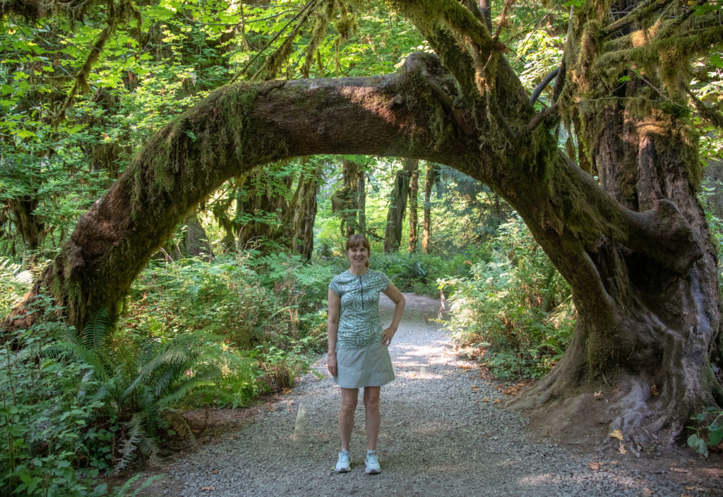
9) Hoh Rainforest Hall of Mosses Loop Trail
Olympic National Park
1.1 mile
Elevation Gain: 78 Feet
Easy
Hoh Rainforest Visitor Center
America the Beautiful Pass (Buy REI)
Olympic National Park is the largest temperate rainforest in the lower 48 of the U.S. Hoh is the name of the indigenous western Washington Indian tribe. Don’t rely on mobile phone coverage once you immerse yourself in the heart of Olympic National Park.
Arrive before 10 am or after 5 pm at the Hoh Visitors Center parking lot during the summer months. I got there at 4:30 with the parking lot opening up and found most of the crowds waning, especially after 6 pm in August.
The star attraction is the Hall of Mosses Trail through mossy old-growth rainforests, draped in lichen and carpeted with ferns. There is a specific section in the trail for the Hall of Mosses. A gothic and primeval setting among cathedral like trees, enswathed by moss and draped with lichen. It’s a marvel and worth taking your time and walking more than once for the full majesty.
Related: Amazing 2-Day Olympic Coast Guide near Forks, WA at Beaches & Hoh Rainforest

10) Hole-in-the-Wall from Rialto Beach Trail
Olympic National Park
3.3 miles
Elevation Gain: 108 Feet
Moderate
America the Beautiful Pass (Buy REI)
This beach is especially known for incredible tide pools, so check the tide schedules when planning a hike. The hole in the wall is only accessible at low tide and is chock full of tide pools on the rocks, with marine life, such as, anemones, shellfish and sea stars. It’s definitely worth planning your day around arriving here for low tide findings. And the parking lot is small, so arrive early before low tide.
11) Hurricane Ridge Trail
Olympic National Park
3.4 miles
Elevation Gain: 826 Feet
Moderate
Near Port Angeles
America the Beautiful Pass (Buy REI)
Just 1.5 miles past the Hurricane Ridge Visitor Center at 5,242 feet high is the trailhead for Hurricane Ridge. This trail is known for its vibrant wildflowers and sweeping views of Olympic National Park, including Mount Olympus, the largest peak in the park at 7,980 feet. This trail is very well maintained and paved for a comfortable hike with breathless views. This is a nice trail for families and amateur hikers.

12) Dungeness Spit Trail
10.2 Miles
Elevation Gain: 137 Feet
Moderate
Dungeness Recreation Area near Sequim
Refuge Entrance Pass
This unique hike takes you on the longest sand spit in North America, that is approx. 5 miles long and growing 13 feet/year into the Strait of Juan de Fuca. The narrow spit offers 360-degree panoramic, breathtaking views of the strait. It starts from the Dungeness Recreation area through a mile of forest that descends to the beach.
Also, the marine and bird wildlife, along with driftwood on the sandy spit is fun to explore. Additionally, there’s even a destination to work towards at the tip: a Lighthouse. The lighthouse is still in use and includes a museum and stairs to the top for a bird-eye view. This hike can be very windy, so be prepared.
Related: A Fabulous Day at Sequim’s Lavender Festival and Dungeness Spit
13) Spruce Railroad Trail: Lake Crescent
11.2 miles
Elevation Gain: 410 Feet
Moderate
Lake Crescent near Port Angeles
Northwest Forest Pass (Buy REI)
This trail goes along the shore for 4 miles along an old railroad route. It’s a continuation of the 130-mile Olympic Discovery Trail, so bicycles and pets are allowed. About a mile in, a bridge spans the lake along Devil’s Punchbowl, a vibrant blue pool that is great for a swim. Lake Crescent is the second deepest lake in Washington state, that is also wonderful for camping and water recreation
14) Mount Storm King
5.3 miles
Elevation Gain: 2,076
Hard/Technical
Near Port Angeles
Northwest Forest Pass (Buy REI)
Many say this hike offers the most incredible views in Washington State, overlooking Lake Crescent and the central Olympics. From the Marymere Falls Trail, the Storm King Trail branches off. It steeply takes you through old-growth forests with many viewpoints. From the second viewpoint at 2,400 feet is the scramble to the summit with ropes to pull yourself up on exposed terrain for breathtaking 360-degree views.
North and Central Cascade Hiking Trails

15) Heather Meadows – Mt. Baker/Mt. Shuksan
Numerous Trails for all levels
Mt. Baker Scenic Highway (Eastern end)
America the Beautiful Pass or Northwest Forest Pass (Buy REI)
Heather Meadows is a vast, scenic area with majestic views of both Mt. Baker (10,778 feet) and Mt. Shuksan (9,131 feet). It is a gateway to numerous hikes for all skill levels. It is particularly known for the incredible views at Artist Point (2.3-mile trail) and Picture Lake (.4 mile), the most photographed lake in Washington with incredible reflections of Mt. Shuksan.
Related: North Cascades’ Picture Lake and Artist Point Trails –
A Late Summer / Autumn Getaway
Also, the Mt. Baker Ski Lodge is there for winter recreation. The Heather Meadows Visitors Center is a great place to learn and plan your time here. More popular challenging trails include Ptarmagin Ridge, Table Mountain and Chain Lakes Loop.

16) Heather – Maple Pass Loop
7.2 miles
Elevation Gain: 2,000 feet
Hard
North Cascades Highway 20 (Rainy Pass)
Northwest Forest Pass (Buy REI)
This trail is renowned as being the best Autumn hike, because of it’s green to golden larches. However, spring and summer are also amazing times because of the spectacular views on this hike. Going clockwise ensures getting the steep part over in the beginning of the hike. However, many claim the counterclockwise offers the best views going up.
When going counterclockwise, at 1.25 mile is the branch to Lake Ann. The detour is mostly flat and just an additional .6 mile, so well worth it as this also gives you perspective on where the trail is going.
The ridgeline of Heather and Maple Pass is the apex here, with 360-degree views of the Cascade Range and Lake Ann. Overall, this trail has it all from the views, alpine lake, old-growth forests and incredible flora and fauna with the beautiful larches in fall and wildflowers in summer.
Also, cell phone coverage is sketchy in this area. Driving east, my coverage ended just before the gateway to North Cascades N. P.
17) The Enchantments Trail (Point to Point)
20.5 miles
Elevation Gain: 4,495 Feet
Strenuous
Near Leavenworth
Lottery for Camping/Hiking – Recreation.gov
This coveted hike is in the Okanagan-Wenatchee National Forest of the Central Cascades. It is recommended only for very serious adventurers. You can day hike the entire grueling trail without a permit. However, because the terrain is so vulnerable, you must apply and win the lottery for camping/backpacking the entire trail.
This area is lauded as some of the most beautiful, otherworldly and rugged landscapes in Washington state. This hike is the ultimate dream of any serious Washingtonian hiker.
Mt. St. Helens Hiking Trails
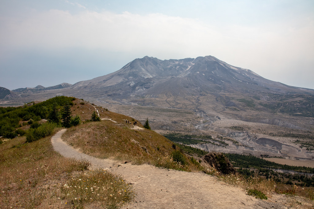
18) Harry’s Ridge Trail
7.8 miles
Elevation Gain: 1,564 Feet
Moderate
Johnston Ridge Observatory
Northwest Forest Pass (Buy REI)
Eruption Trail leads to the longer Harry’s Ridge Trail as the best way to observe the volcano. Mt. St. Helens eruption in 1980 is the most devastating in U.S. history. The trail is named after the curmudgeon, Harry Truman, who wouldn’t leave his home and died in the eruption.
The trail almost continuously views Mt. St. Helen’s smoldering crater and overlooks the heart of the blast zone, lava dome, pumice plain and landslide across the valley.
Additionally, this trail displays the colorful wildflowers in summer months and vibrant fall foliage. It goes to the beautiful spot, overlooking Spirit Lake with breathtaking views of its cobalt blue water below the ridge. This trail is reasonably wide and well-maintained, however, there are times it gets very close to the steep edge. So, if you have a fear of heights this trail may be a challenge.
Related: Mt. St. Helens’ Scenic Daytrip Itinerary
19) Ape Cave Trail
3 miles
Elevation Gain: 433 Feet
Moderate
Northwest Forest Pass (Buy REI)
This out and back trail is a one-of-a-kind adventure taking you through one of the longest lava tubes in the world. Take 3 sources of light per person along for back up. And dress for temperatures in the low 40’s, with sturdy shoes for traversing over some rocks. You can opt to just walk one way and return above ground. This fascinating phenomenon actually was formed from an eruption 2,000 years ago from a rare red lava flow.
20) Cape Horn Loop Trail
7.5 miles
Elevation Gain: 1,587
Moderate
Columbia River Gorge
No Permits Required
This trail offers fantastic views of the Columbia River Gorge along the northern side of the rugged cape. It also features Cape Horn Falls. The out-and-back route is necessary for much of the spring and early summer because of a closure for nesting peregrine falcons. The upper trail offers a more manageable terrain and sweeping views of the gorge.
And the lower trail requires traversing over moss covered talus fields and narrow paths, with steep edges. Therefore, some amateurs choose just the upper trail, out and back, that still offers incredible views.

Enjoy Washington State Hiking Trails!
Really, these top 20 are just the tip of the iceberg in this incredible state. So, how to plan where to hike? Consider the distance, weather, your physical limits and what are you wanting out of a hike. Overall, with these 20 top Washington hiking trails you are guaranteed an incredible experience. Hiking has such a way of elevating you to the realms of dreaming and thinking larger than life. But always, bring your Hiking Essentials for a safe journey.
Read More!
Ultimate Guide to Mt Rainier National Park: All You Need to Know
Incredible Dosewallips State Park Camping & Hiking Trails in Washington