

As the largest marble canyon in the world, a Taiwan Taroko Gorge tour is a one-of-a-kind destination. Exploring here is a journey into ancient myth, telling stories in rocks of color and light. One can imagine how awestruck Michelangelo would have been regarding these colossal marble canyons. I explored in one day the Swallow Grotto, Eternal Spring Shrine, “Tunnel of 9 Turns” and Shakadang Trail at Taroko National Park.
About Taroko Gorge
This geological magnum opus is just a half hour drive northeast of the eastern port city, Hualien. Taroko Gorge bisects the earth, opening its gorgeous marble depths in narrow passageways for 19 km. It runs between the Pacific Ocean on the east and the Syue (Snow) Mountains to the west.
Overall, the dramatic marbled canyon walls, embedded with schist and green gneiss, displays the artistry of wind, water and time. Over 70 million years, the Liwu River has eroded the marble and carved the stone. In addition, the uplifting of ground gradually designed its epic landscape.

Taiwan’s Taroko Gorge is an eloquent Taoist expression of the balance and harmony of nature, especially regarding the element of water. Erosion shaped most of the rocks over millions of years. As a result, the Tao de Ching’s expresses this perspective on the water element. “Water is fluid, soft and yielding. But water will wear away rock which is rigid and cannot yield.” Allowing my essence to connect with the majesty of Taroko Gorge, I aligned with the Great Tao.
Its varied terrain ranges from the sea level Liwu River to its highest peak of Mt. Nanhu. This huge altitude difference and the influence of monsoons cause a significant flux in temperatures. Overall, the climate ranges from subarctic to sub-tropical. The region has a unique geological phenomenon, with soil that doesn’t easily accumulate. Therefore, water doesn’t easily save. Moreover, vegetation includes mainly light-demanding and drought enduring plant species that grow on rocky area. However, the frequent stratum movement prevents it from flourishing.
Taiwan’s Taroko Gorge Day Tour

Tunnel of Nine Turns
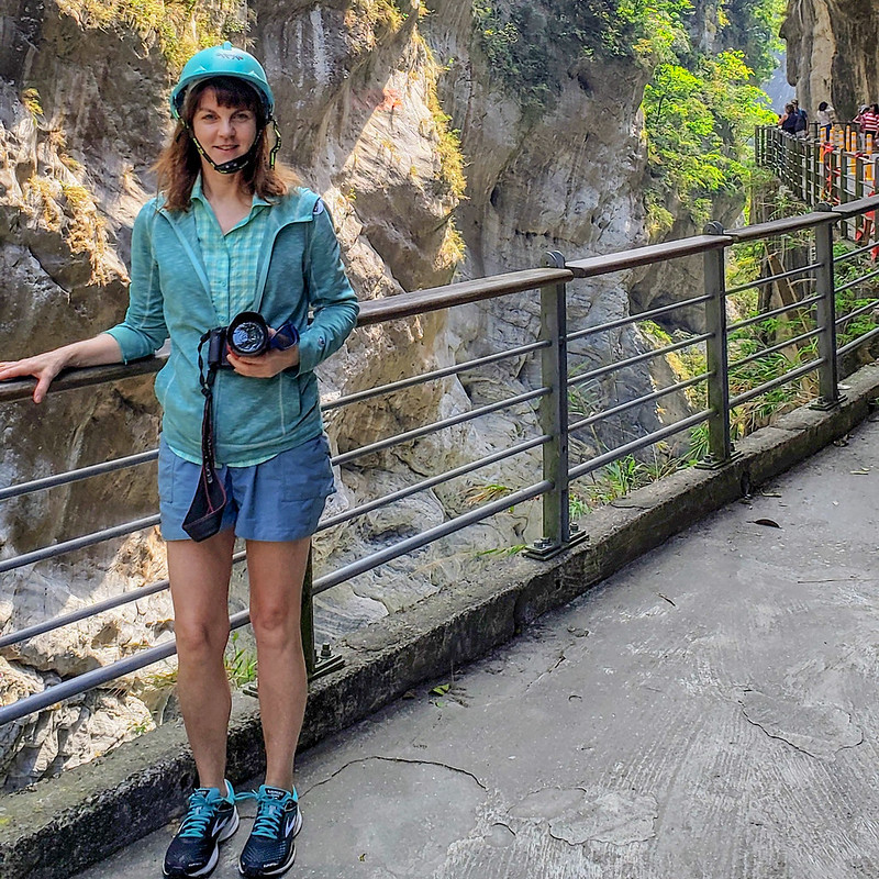
The river eroded narrow gorges and curves, giving way to the Tunnel of Nine Turns. Once a tunnel used for transportation, it is now a walking path. Note that there is no parking lot at the entrance, however, busses can drop visitors off here.
It takes about 30 minutes to walk the path. It is epically scenic with incredible views up close of the stone strata, river and dramatic geology. They offer free safety helmet to wear while walking the trail, as shown in my photo.
Central Cross Island Highway

The Central Cross-Island Highway zigzags across the gorge with dramatic twists and turns along steep edges to a marble abyss. Moreover, it’s said to be one of the most dangerous highways in the world. Construction started in 1956 with 5-6 thousand men working simultaneously at different sections. In addition, periodic typhoons and earthquakes often cause deaths and destruction. Overall, construction took almost 4 years, opening in 1960.
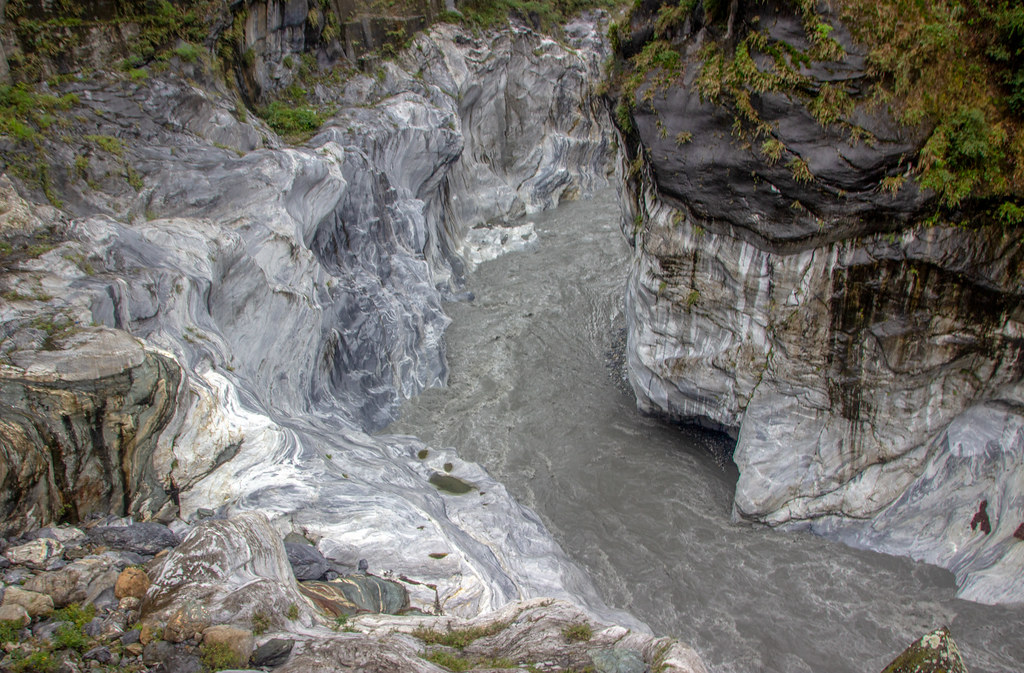
Swallow Grotto
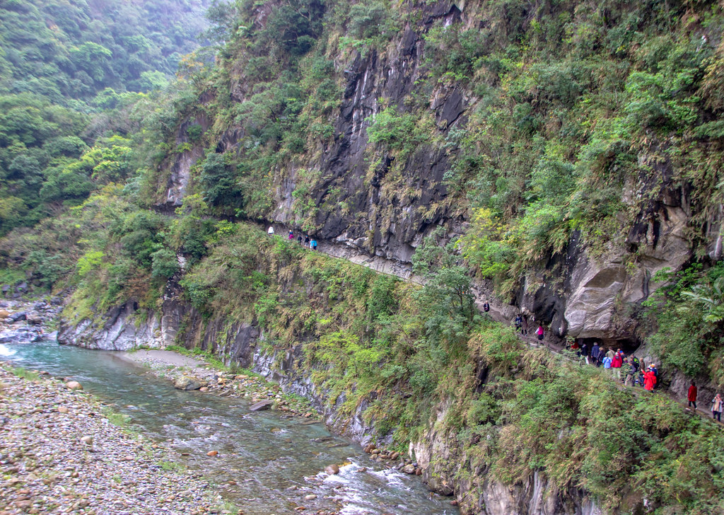
In a section of the Central Cross-Island Highway is Swallow Grotto, forming narrow passageways, (as small as 12 meters apart in some areas) carved out by the river with 2 steep, almost vertical canyon walls of marble, gneiss and schist on each side. Excitedly, I walked for about 45 minutes along a canyon in and out of tunnels, above the turquoise Liwu River, looking up and down the vertical canyon wall on the other side.

It’s required to wear a helmet, as a precaution for falling rocks. This grotto is named after swallows known for high-speed catching insects, from rising air currents. They make mud nests on top of the tunnel’s rock wall and used to visitors.
Walking beside the grotto walls, you can see potholes sporadically hollowed out in the rock. Groundwater seeps out cracks, dissolving rocks, and river sand abrasion to hollow out rock. As a result, water flows out of these potholes, with volume depending on rain. Holes high above river show the river flowed that high at one time.
In addition, a striking rock formation is Indian Chief Rock, sculpted by the Liwu River. It reveals the face profile of an Indian Chief along with green vegetation above forehead looking like a headdress. The river carved the exquisite marble in many shades of swirling grays and browns, with the water preferring soft rock that erodes more easily leaving behind the hard rock.
Eternal Spring Shrine
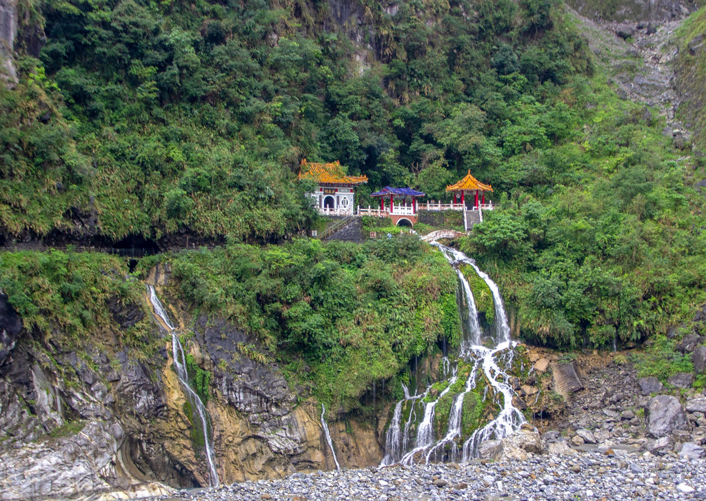
The Eternal Spring Shrine was completed in 1957 to commemorate all those workers who died building the treacherous highway. Moreover, the shrine has been rebuilt twice because it was damaged in landslides. It’s a bright spectacle of blue, red, gold and white elegantly propped above the gushing spring water.
The Liwu River is continually eroding the foot of the slope receives a constant supply of spring water that gushes through the cracks in the rock. As a result, with heavy rain the water volume increases dramatically making a sound like thunder. I took the short trail to the shrine along the cliffside looking down at the gushing eternal spring water.
Shakadang River Gorge Trail
My first morning at the gorge I hiked the 30-minute Shakadang River Gorge Trail on a path etched out of the canyon walls. It was a beautiful walk above the blue-green river and marbled gorge. First, we crossed a fire engine red bridge (above photo) over the river to access the trail. It rained, revealing the streams and geological folds among low altitude nanmu and fig forests, with ferns and other underlying foliage.
The rock wall along the trail is filled with lush vegetation and referred to as “Fern Wall” with many species: Bird’s Nest Fern, Japanese climbing Fern, Tuberous Sword Fern, Maidenhair Fern and others. After that, the trail immediately closed due to landslides, so we were the only ones that day who got to hike this trail.

Overall, I only Scratched the Surface…
Lastly, I missed the iconic landmark called Cingshui Cliff. It’s the only place of Taroko that borders the ocean, about 30 minutes north of our journey. The near-vertical cliff, towers at more than 1,000 meters, became formed by endless lashing and beating of the ocean on its rock. This rare geological phenomenon occurs along the eastern coast stretching for 21 km.
Overall, my 2 days at Taroko Gorge National Park felt as though I only scratched the surface. I hope to return and see the Cingshui Cliff and do more hiking. However, this region has precarious risks, such as, mudslides, falling rocks and poisonous snakes. So, my suggestion for anyone visiting this magnum opus of Mother Nature is to have a guide to safely explore its ancient and wild beauty.
Read More!
Amazing Day at Taiwan’s Yangmingshan, Geothermal Spas, Yehliu Geopark
A Fascinating Taiwanese Tea Tour in Taipei & Health Benefits